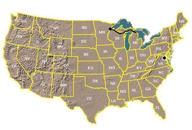
The Big Picture - Follow the Black Route from West to East
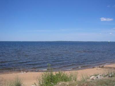
I left my parents' house in Duluth, MN at 8:45 am CDT, and headed west on Skyline Parkway, south on 40th Avenue West to US 2, and across the Bong Bridge to Superior, WI. The sky was completely overcast, and fog was rolling across the bay:
In downtown Superior US 2 merges with US 53, and I continued southeast. In Superior I saw a sign that said that it was 55 degrees (at 9:30 am CDT), which is about my lower limit for comfortable bicycling when wearing shorts and a t-shirt, especially when there's a stiff headwind or crosswind (which there was).
I followed US 2/53 to the point southeast of Superior where it becomes limited-access (no bicycles allowed), and at that point I headed south on Douglas County Road E, wondering if I'd be able to spot Corky's house (Corky had given me directions when I was headed the opposite way back on June 17). As luck would have it, he was out in the yard (!), so I stopped and chatted with him for a while.
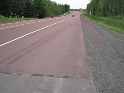
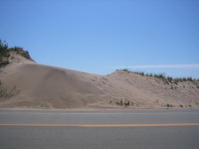
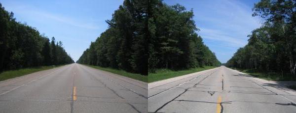
I continued south on County E, and then east on Douglas County Road C, which meets up with US 2/53 just beyond the limited-access stretch. Continuing eastbound on US 2, I went through Wentworth. Somewhere in this area the asphalt roadway changed color from the usual dark gray "blacktop" to reddish:
What could account for the reddish color? Consulting the map, I saw that I would be traveling:
I stopped in Poplar to pick up a healthy lunch of PowerAde, mini-donuts and a Charleston Chew (for dessert!), and a bank's sign said it was 66 (at 11:30 am CDT). Let's see ... it's nearly noon, in the middle of *July*, and it's a whopping 66 degrees. Maybe I should have chosen a more southerly route ... like through Texas, maybe! And did I mention the headwind?
Then it was on through Maple, and into Brule. Just past Brule the sun peeked out, and at the same time it started to rain! It was just sprinkling, though, and when the sun disappeared a mile or two down the road, so did the rain. Figure that one out! Too bad that the headwind didn't vanish with the sun and the rain. Speaking of rain, I don't suppose that helps these big hay bales dry out:

East of Brule there was construction on US 2, and I detoured onto Old US 2 (which runs parallel to the current highway) for a few miles. In Iron River I stopped to chat with some kids who were playing miniature golf, and then it was onwards through Ino.
I've seen all kinds of things along the road during my bike trip, but this section of US 2 was unique in that the most common item to be found on the shoulder wasn't a beer can. Instead, it was birch bark:

At the point where US 2 meets US 63 it started sprinkling again, but nothing worth donning the rain poncho for. I continued east on US 2, and reached the Best Western (just west of Ashland) at 4:00 pm CDT.
After taking a shower, as I was on my way to the restaurant next door, I noticed that it had rained after I arrived at the motel. Turns out the rain had started five minutes after I arrived. Perfect timing! There were about fifty Canada geese standing in the backyard of the restaurant, and my server said that they come ashore when the weather gets stormy. Before I could get a picture they were headed back to sea, looking like the D-Day storming of the beaches of Normandy in reverse!
The distance for this first leg of the trip was 75.1 miles, actual travel time 6 hours and 19 minutes, for an average speed of 11.9 mph. That's not bad, considering I was fighting a headwind nearly the whole time. The last day of the westbound trip I did 175 miles, but that was without any headwind, and it didn't seem any harder than today's seventy-five. Both of my Achilles tendons are a little sore, but that happened at the beginning of the westbound trip and didn't cause me any problems. When I was planning this trip, for some reason I was thought that today's segment was close to 100 miles. I wonder where the missing 25 miles went?
I left the motel at 9:00 am CDT, and headed east on US 2 into the city of Ashland, where I bought a few greeting cards. After passing through Odanah and crossing the Bad River (how bad can it be?), I stopped at the store next to the Bad River Casino for toothpaste (which I had somehow forgotten to pack). The Casino sign said that it was 56 degrees (at 10:46 am CDT). I chatted with a couple of guys outside the store for a few minutes (including one who was wearing a "Redneck" ball cap), and they warned me about a "big hill" about six miles east.
I climbed "The Hill" at 5 mph (a steep one slows me down to 3 mph), then passed through Birch, and past Saxon. It was somewhere along here that I spotted something that I'd heard of, but never before seen ... what is probably the most famous road in the world! No, not Pennsylvania Avenue in Washington, DC. No, not Route 66. Instead, I'd found Lover's Lane!
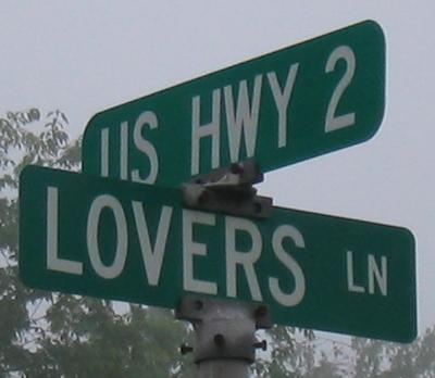
Before this, I didn't even know if it really existed! Who would have guessed they had it hidden away in Iron County, Wisconsin? Those Wisconsinites must be a romantic bunch! And speaking of romance, as I was heading into Hurley, I was passed by a pink dump truck that was pulling a trailer holding a pink bulldozer. I didn't get a look at the driver, though. Care to make a wager on her gender?
I stopped in at the Dairy Queen in Hurley for lunch (fries and a strawberry shake), and after I departed it began sprinkling, and I picked up a slight tailwind. As I passed a meteorology station, I checked its anemometer just to be sure:
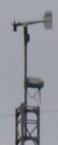
Yep, it's a tailwind all right! I'm coming across all kinds of hard-to-find things right here in Wisconsin! And speaking of weather, it could always get worse:
In Mercer I stopped for dessert, which consisted of ... Dots! Yeah, I know they're pure sugar, but I figured that since I'd already covered sixty-some miles, with about the same to go, I needed the energy! It was still sprinkling when I got to Manitowish, where I had planned to take WI 47 south to Woodruff (since I'd spent the last 25 miles on US 51), but the signs said that WI 47 was closed twelve miles ahead (bridge out, maybe?), so I stayed on US 51.
By the time I got to Woodruff it was no longer sprinkling ... it was raining! I stopped for a PowerAde and a cookie (an impulse buy!), and then it was on through Lake Tomahawk, which bills itself as the "Snowshoe Baseball Capital" of the world.
I arrived (thoroughly drenched) at the Holiday Inn Express on the west side of Rhinelander at 8:00 pm CDT. When I got there, Matt the Maintenance Guy told me that there was a big country music festival happening in town, during which Rhinelander's population goes from the usual ten thousand to about thirty thousand for the weekend.
The distance for this leg of the trip was 125.1 miles, actual travel time 9 hours and 37 minutes, for an average speed of 13.0 mph. Hmmm ... I had thought that today's segment was only about a hundred miles. It looks like I found yesterday's missing 25 (and a soggy twenty-five miles it was!). And my right thigh muscle has pretty much had it, with hardly enough strength left to bend the knee. Tomorrow should be an interesting day. Total distance to this point: 200.2 miles.
I left the motel at 9:00 am CDT, and headed east on US 8. Based on the signs I saw, it's not much of a mystery what the tourists like to do in this area ... nothing!
A little further on, I found another interesting item sitting on the side of the road:

Looks like Wisconsinites are still a happy bunch (must be all that romance!). As I was heading into Monico, a county cop went screaming by eastbound. When I got to the spot where US 45 crosses US 8, I saw why. It looked like somebody had blown the stop sign, and smacked into another car:
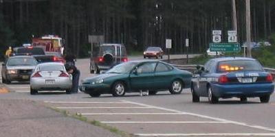
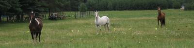
There was already a fire truck at the scene, as well as a state trooper and the county squad. As I was leaving the scene, an ambulance was just arriving, and as I headed east on US 8, a city cop and another state trooper passed me, headed towards the accident. With all of those emergency vehicles responding, somebody must have been injured, but I didn't see anything. All I know is that I'm glad that these inattentive drivers are crashing into things other than me! Further east, I spotted a few friendly horses romping in their pasture:
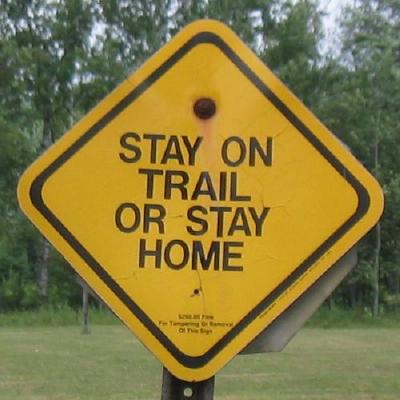
Continuing eastbound on US 8, I came across the following sign:

Does anybody have any idea what a "Legendary Civilian Jeeper" might be? Or any "Jeeper" at all? And while we're on the subject of mysterious roadside objects, here's another:

Okay, so it's a mailbox. But what's with the smaller mailbox on top of the post? Air-mail deliveries via carrier pigeon, maybe? Still pondering signs and mailboxes, I continued eastbound to Crandon, where I bought some cookies at a bake sale, and a box of "Good and Plenty" for dessert. I also chatted with a few guys about my trip, one of whom used to work for the Forest Country Highway Department. When I told him I was bound for Iron Mountain, he advised me go north on WI 55 (rather than east on WI 32), because it had better scenery, so that's what I did. Just after turning left onto north WI 55, I came upon the following:
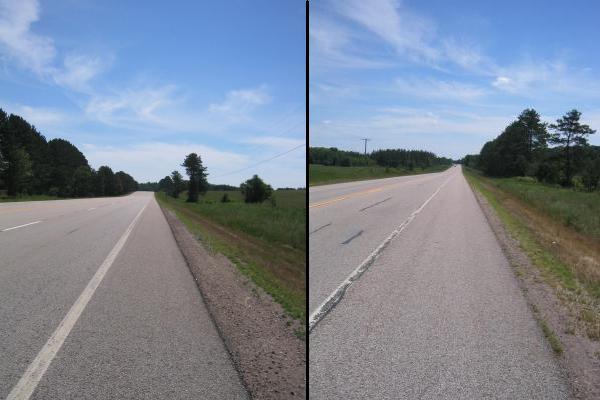
The northward jaunt on WI 55 was pretty much into the wind, but after I turned east on County Road G at Aragonne the wind mostly died down (probably blocked by the trees). Here's the view looking eastward on County G:
After a nice ride on County G, with the sun attempting (but failing) to come out, it was back onto US 8 eastbound. Actually, turning left from County G onto US 8 points you northbound, but then US 8 makes a sweeping turn to the right and ends up heading east. At Armstrong Creek I turned north on WI 101, and saw yet another mysterious sign:
What makes it mysterious is that there was no trail in sight ... on either side of the road! My best guess is that it refers to a trail that only exists in the winter, such as a cross-country ski or snowmobile trail. Just outside of Fence I headed eastbound on County Road C, and shortly thereafter it started sprinkling, and I thought "Here we go again!". While on County C, the wind whipped up, and at one point nearly blew me off the road.
Shortly after that I saw a deer crossing the road about a half-mile ahead, but by the time I got there it was gone. A little further on a dump trunk came up behind me, and while passing me he swung into the oncoming lane. As he swung out, a car came around the curve ahead, and the dump trunk had to veer right once he was past me to get back into his lane. He got a little carried away with that move, and ended up going onto the shoulder in front of me. No damage done, but it was exciting to watch. Will he get out of the oncoming car's way? Will he go off the road to the right?
County Road C ends at the point where it hits County Road N, and I continued eastbound on County N to Aurora. Once through Aurora, I was into Michigan, and headed northbound on MI 95.
The sign on the credit union in Kingsford said that it was 58 degrees (at 4:59 pm CDT), and then I was into Iron Mountain. Turning eastbound on US 2 brought me to the Best Western motel at 5:30 pm CDT. After I checked in, I flipped on the TV, thinking I'd check on the "Tour de France" (for inspiration!), but the "Outdoor Life Network" was showing the annual "Running With The Bulls" from Spain. Some people might think it's crazy to ride a bicycle cross-country, but that doesn't compare to running down city streets while being pursued by a dozen or more 1500 pound bulls. E-gads!
The distance for this leg of the trip was 88.9 miles, actual travel time 7 hours and 24 minutes, for an average speed of 12.0 mph. Total distance to this point: 289.1 miles.
I left the motel at 8:45 am CDT, and headed east on US 2, finding the start of a construction zone about a mile down the road. In the area of the intersection where US 141 heads south towards Niagara, WI the shoulder wasn't paved. In order to be a "nice guy" (and keep out of the way of the traffic), I decided to ride on the dirt. Big mistake! As soon as my tires hit the dirt I started sliding sideways, fishtailing left and right at about 15 mph. Since I wasn't going very fast and the surface was gravel I managed to keep the bike upright by using my feet as "outriggers", leaving a few skid marks along the way ...
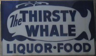
The construction continued eastward until I reached Norway, home of "The Thirsty Whale" Bar & Grill.
Among the things that Mike and I discussed was my route planning for the day. He mentioned that he had an alternate detour around the construction zone east of Norway (the Sturgeon River bridge was out between Vulcan and Loretto), which turned out to be County Road 573 (running from Norway to Loretto). Then it was back onto US 2 east, which came in two primary varieties: a nice four-lane (with a four-foot paved shoulder), or a nice two-lane (with an eight-foot paved shoulder) ...
Somewhere along here I saw a small deer bounding through the woods, and then I went through Spalding, home of the Full Belly Deli:

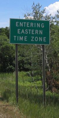
I crossed into the Eastern time zone at Delta County line, and although I've lived on the East Coast for nearly eleven years, Eastern time still seems foreign ...
Shortly thereafter I wheeled into Escanaba. Since I'd had a big dinner the night before, I hadn't eaten any breakfast today (although I did have a muffin and a couple of cookies at Mike's). I was hungry, and when I saw a "Subway" sign ahead I locked right in:
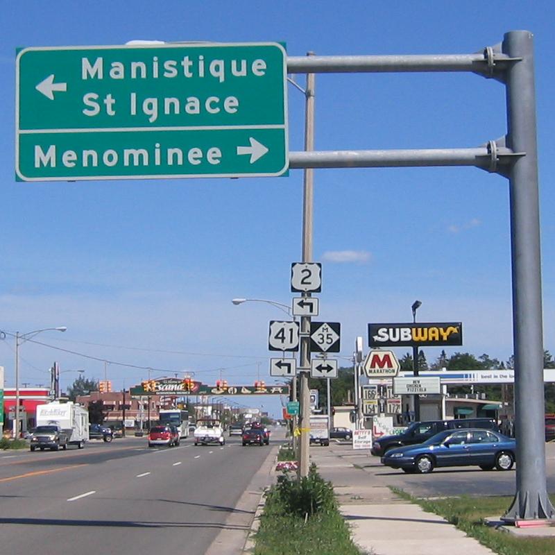
I nabbed lunch at Subway, then blew through the next intersection and into downtown Escanaba. A few miles down the road it had become apparent that I was no longer on a major US highway. The clincher was when I suddenly found myself at a dead end, with water on three sides.
Hmmm ... what had gone wrong? I asked a local cyclist, and he said I'd missed a turn at a major intersection. I headed back through downtown Escanaba, only to have my suspicions confirmed: In my hunger-crazed state I had ignored all the signs (including the one pertaining to US 2) *except* for the one for Subway. And just because Manistique is my goal for the day doesn't mean I have to pay attention to signs for it, does it? Hunger-induced tunnel-vision, apparently. Yeah, I know ... the hard left-hand turn on US 2 within Escanaba is on the map, but who looks at maps?
I made it out of Escanaba, and into Gladstone, where I saw my first pulp train (a train loaded with trees destined for a paper mill). That's a lot of trees! Then it was a twenty-mile-long gentle climb (I kid you not!) to the area of Ensign, followed by a 4 mile downhill run. After that it was rolling grades (nothing steep, but nothing flat, either). From Escanaba on I'd seen a lot of tree bark along the road:

The final run was along Lake Michigan, so it was mostly flat, and mostly pretty ...


After chatting with Manistique's Finest for about ten minutes I rode back to the Holiday Inn, arrived at 9:30 pm EDT and called it a day ... a day of excellent riding, beautiful scenery, and perfect weather.
The distance for this leg of the trip was 119.7 miles, actual travel time 9 hours and 36 minutes, for an average speed of 12.5 mph. Total distance to this point: 408.8 miles.
I left the motel at about 9:00 am EDT under sunny blue skies, and headed east on US 2. After about a mile road construction began, which looked like this:
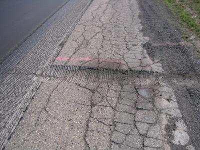
Note that there are five discrete sections. From left to right, they are:

Right about the spot US 2 intersects MI 77, I had my photo taken by four guys in a pickup pulling a trailer-load of ATVs. Here's the photo:
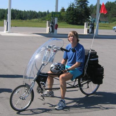
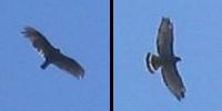
When I learned that they were from Escanaba, I told them my Escanaba Subway sign story. They knew the spot! Right after I left them I saw what I think was a hawk circling above, and I managed to snap a few pictures:
Just after I crossed into Mackinac County, I heard a loud metallic *CLANK* from somewhere. My first thought was "Uh-oh, what's happened to my bike?" Because everything seemed to be working fine, and the noise had been almost too substantial to have been caused by the relatively flimsy metal of a bicycle, I began looking for other sources. Hmmm, let's see ... there were a couple of semi's parked on the other side of the road, but I didn't see anyone around them. But what's this sitting on the shoulder up ahead?
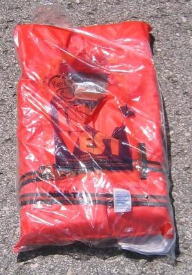
The sticker said it cost someone all of $6.95 (plus tax), and since it was in excellent condition, I figured I'd grab it and give it to the next boater I came across. The question was where to put it? Being nearly two feet by one foot, there is no way that it would fit inside any of my saddle bags. I suppose that I could *wear* it, but that would undoubtably get me some very strange looks! A reasonable solution was to wedge it in behind the seat, on top of the center bag, like this:

Voila: The world's first life-jacket-equipped bicycle! After all, you never know when you might need a little extra buoyancy. "Attention cyclists! In the unlikely event of a water landing, your seat back can be used as a flotation device ..." As an added bonus, the blaze orange color aids motorists in seeing (targeting?) me from behind.
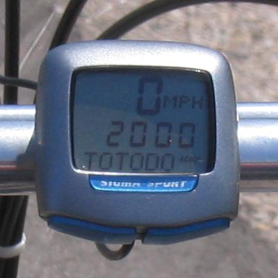
Somewhere along here I received divine inspiration to check the total mileage for the trip so far. When I did, I saw that I'd put on exactly 2000 adventure-filled miles since leaving DC back in June:
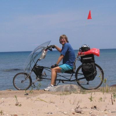
The northern-most tip of Lake Michigan lies just east of Naubinway, and at that point I stopped to snap a picture of my bike on the beach:
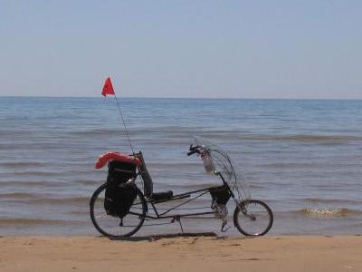
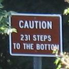
Yes, it's as pretty here as it looks! Between the towns of Epoufette and Brevort runs the Cut River, which you cross via the Cut River Bridge. To the left of the bridge is a long stairway leading down to the Cut River:
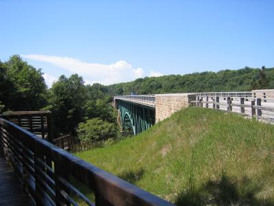
The bridge is a scenic lookout, and you can park your car near it, then use the pedestrian walkway to view Lake Michigan from the bridge:

You can also take the stairs to the side of the bridge down to the Cut River:
Or just view the river from the bridge:

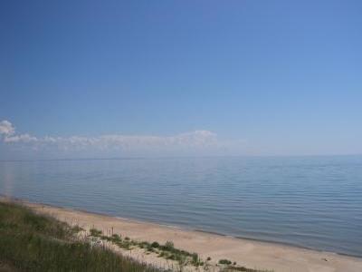
The run from Naubinway to Gros Cap has many tourists and locals taking advantage of the sandy beaches to swim, tan, Frisbee, etc. It's all very pretty:
Just west of St. Ignace lies the (supposedly) world-famous "Mystery Spot":
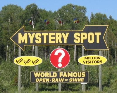
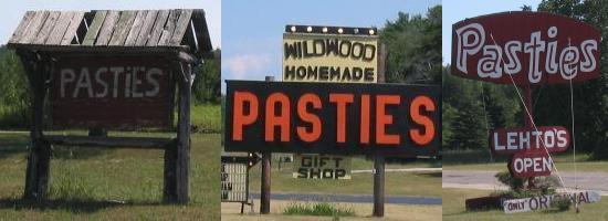
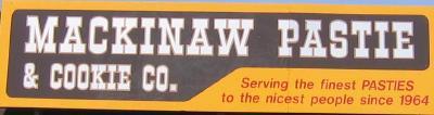
I wonder what they have there. UFO's, maybe. Or perhaps it's Dick Cheney's "secure undisclosed" location. Or maybe it's where they hide the secret recipe for "pasties", a food that seems to be advertised nearly everywhere in the Upper Penninsula:
As I understand it, a pastie is a meat, potato and veggie filled pasta-type thing, which is boiled (sort of like a big pirogie). Regardless, since I didn't stop in, I guess whatever it is that they're hiding at the "Mystery Spot" will remain a mystery, at least to me!
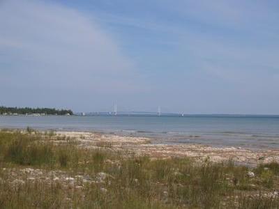
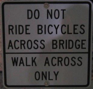
US 2 ends just west of St. Ignace (on the Upper Peninsula), where I-75 crosses the Mackinac Bridge. To get to Mackinac City (on the Lower Peninsula), I had to cross The Bridge ...
The Mackinac Bridge is a five-mile long suspension bridge that connects Michigan's upper and lower peninsulas (it's the only connection between them within Michigan). By the way, "mackinac" is pronounced "mack-in-aw", with the final "c" silent. In fact, you'll sometimes see it spelled "mackinaw", which looks much closer to the correct pronunciation.
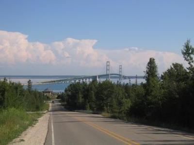
For you bridge afficianados (you know who you are!), here are some statistics on the Mackinac Bridge:
Bicycles are not allowed to cross the bridge (it can get really windy up there), but I knew if I could get my bike to the toll booth, the Mackinac Bridge Authority (MBA) would transport it across for me. The question was how to get it there, since the entrance to the bridge is a freeway. I stopped in at the Subway at the top of the hill for directions, they told me to go down the back road by the car wash, and inquire at the Michigan State Police HQ at the bottom of the hill. The Trooper at the desk told me to cross the freeway (yep, that's what she said!) to the MBA building on the other side, so that's what I did. About five minutes after I paid the $2 bicycle toll, Tom (an MBA maintenance worker) came along in an MBA pickup truck.
We loaded my bike into the back, and headed across the bridge. Tom said that mine was only the third bike he's hauled across on his shift in the last month.
The Mackinac City Holiday Inn Express is right at the foot of the bridge, and we pulled into the parking lot and unloaded my bike just before 7:00 pm EDT.
The distance for this leg of the trip was 93.9 miles (not counting the five miles across the Mac), actual travel time 7 hours and 37 minutes (again, not counting the time spent on the bridge), for an average speed of 12.3 mph. Total distance to this point: 502.7 miles (an average of just over 100 miles per day!)
I left the motel at about 9:00 am EDT under sunny blue skies, and about the first thing I saw was an advertisement for pasties:
Lake Michigan and Lake Huron come together at the Straights of Mackinac, which lie right below the Mackinac Bridge. Going west from Mackanac City takes you along the Lake Michigan coast, and going east takes you along the Lake Huron coast. I headed eastbound on US 23, and here's a parting shot of the Mighty Mac as seen from alongside Lake Huron:
The road was a nice two-lane with a good shoulder, long straight level stretches, and very little breeze (and very few cars!), so I could make pretty good time (about 15 mph without much effort) ...
As I was cruising along on the main street of Cheboygan, I spotted a house with a rather unique yard decor:
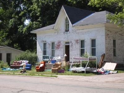
I counted five recliners and a bunk bed. That makes seven horizontal surfaces, one for each day of the week. Do you suppose that the owner sits out front and watches the world go by from a different place each day? Do you suppose the owner is aware that most people keep their stuffed furniture *inside* the house? Do you suppose the owner moves the stuff in at night and when it rains (or is it outside all the time)? Or maybe he was getting ready to have a yard sale ...
A mile or so down the road, as I was riding across a short drawbridge, I caught sight of a sign out of the corner of my eye. Because I didn't really see what it said (it was off to the side of the bridge, kind of in the shadows), when I got to the other side of the bridge I pulled a quick U-turn, and *rode* back across. Wouldn't you know it, the sign said:

There you are, minding your own business, just pushing your wheelbarrow across your front yard, when *WHAM* ... out of the clear blue, you get hit by an asteroid! I hate it when that happens ...
There are so many interesting things to see out here on US 23. After passing several scenic overlooks (graced with Lake Huron, trees and other natural wonders) I came upon this little gem:
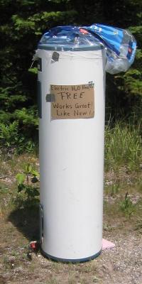
Yep, it's an electric water heater. Guess they switched their cabin over to gas! As I headed past Huron Beach I decided to test my new digital camera's self-timer. I pulled into "Huron Shores Roadside Park", rolled the bike down to the beach, set the camera on a rock, hit the switch (10, 9, 8 ...), and scampered back to the bike. Here is the result:
I'm not a linguist, but neither am I totally inept when it comes to language. Nevertheless, French completely baffles me. It's as if when many of the French words were coined someone was running a sale on letters, so they randomly threw in some extras. Here's an example:
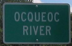
The correct pronunciation, by the way, is "OCK-EE-OCK", which I believe is French for "unpronounceable string of consonants and vowels"! And speaking of signs, up to this point things had been pretty much smooth sailing, but then I came upon this ...
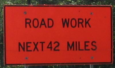
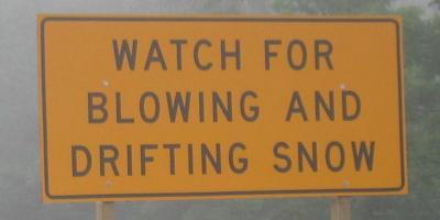
Forty-two miles of road construction ... e-gad, that'll last almost all the way to Alpena! Well, hopefully some of it's done. And maybe it doesn't involve the shoulder much. Wait, here's another sign ...
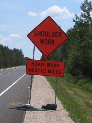
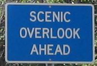
So much for hoping that the shoulder's not involved. But things look good just beyond the sign, anyway. And speaking of signs, one of the more common signs that I've seen out here is this one:
Just past Forty Mile Point, right past the "Hammond Bay Public Access" to Lake Michigan (about six miles northwest of Rogers City), I pulled into one of the scenic areas just for the heck of it. As I was leaving, I saw a black squirrel romping around, but before I could snap his picture, he shot up a tree. I waited a while, then exited the scenic area, and looped back to the entrance and cruised through it again, but he was gone. Other than birds, I'm not having much luck with wildlife photography on this trip. And speaking of luck ...